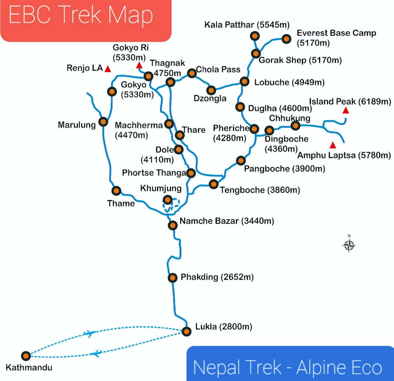
| Day 1 |
Fly from to Lukla from Kathmandu and Trek from Lukla to Phakding:
Altitude: (Lukla/2,830 m) to ( Phakding 2,640 m)
Time taken: 4-4.5 hours, 9 km
Trek gradient: Easy. Gradual descent throughout.
Water sources: You can refill your water bottles at tea houses on the way
Kathmandu is the ancient capital city of Nepal and is a culturally rich and touristic hub. It is the gateway to Nepal Himalayas and stands at the elevation of 1350m. While the city endured a lot of damage during 2015 earthquake, it remains a fascinating place to explore.
Take the first flight out of Kathmandu to Lukla, where your trek begins. Weather plays a crucial role in flights taking off to Lukla. Hence, we take a first flight to Lukla.
Lukla is a tiny village with an airstrip at the end of the valley. This airport is called the most dangerous airport in the world for its short runway and the drop off in the end. Landing and taking off in Lukla is an adrenaline pumping experience. A simple thing like cloud covering a mountain ridge can shut this airport down. The trail to Phakding is mostly descending. After a small forest trail in the beginning, you will walk through Nepalese villages surrounded by a lot of vegetation.
|
| Day 2 |
Phakding to Namche Bazaar:
Altitude: Phakding (2,640 m) to Namche (3,445 m)
Time taken: 7 hours, 10 km
Trek gradient: Moderate. Initial level walk for 30 minutes followed by an undulating trail for a few hours. Steep climb to Namche hereafter.
Water sources: You can refill your water bottles at tea houses on the way.
Namche, where you’ll be headed today, is the capital of the Khumbu region. Start your day early as there is a long day of trekking in store. The trail goes up and down as you gradually gain altitude. You will mostly be trekking through forests.
Monjo village is the mid point of today’s trek. There is a 3-4 km steep climb through forests just before the Swiss suspension bridge over Dudh Kosi river, which is the lifeline of the Khumbu region.
Highlights of the day include entering the Sagarmatha National park, spotting the Kongderei and Thamserku peaks, and getting your first Everest view point.
|
| Day 3 |
Acclimatisation day at Namche Bazaar:
Today, you will do an acclimatisation climb to Everest View Hotel and come back down to Namche for lunch.
Namche Bazaar, which is a pitstop for trekkers and climbers going to Everest Base Camp, is worth exploring. You can shop here for souvenirs or even trek gear.
You can also hike to the Sherpa Cultural Museum from where you get great views of Everest and Ama Dablam. The museum details the history of the region with a peek into the lives of Sherpas. You will see photographs from Edmund Hillary and Tenzing Norgay’s climb as well as maps detailing all hiking trails in Nepal. |
| Day 4 |
Namche Bazaar to Phortse Thanga:
Altitude: Namche (3,445m) to Thanga (3,658 m)
Time taken: 6 hours, 8-10 km
Trek gradient: Moderate. 4 km level walk followed by a steep ascent for around 2 km. Descent all the way post lunch.
Water sources: You can refill your water bottles at tea houses on the way.
The trail climbs out of Namche and descends to Khumjung village. Khumjung is a Sherpa village with 40-50 houses. From Khumjung, the trail climbs up the stairs and hugs the sides of the mountain. It diverges from the main Everest highway at Sanasa, after Khumjung. Up to Sanasa, you will be trekking through forests, after which you reach a village.
You will be able to see Tengboche monastery from here. It is said that Tenzing Norgay spotted this monastery from the summit of Everest.
The trail then climbs to Mong La, a vantage point, where you will have lunch. From here, you descend to Phortse village. |
| Day 5 |
Phortse Thanga to Macchermo via Dole and Lafarma:
Altitude: Thanga (3,658 m) to Macchermo (4,450 m)
Time taken: 5-6 hours
Trek gradient: Difficult. Steep ascent for 3-4 hours followed by a gradual descent for 20 minutes.Ends with gradual ascent all the way.
Water sources: Start with carrying 2 litres of water. You can refill your water bottles at tea houses on the way.
The trail starts from behind tea houses in Phortse Thanga, through dense rhododendron forests. The trail relentlessly climbs and at this altitude, you will feel the climb. From the forests, you eventually reach meadows and small grass lands.
You willl see Cho Oyu massif, the sixth highest mountain in the world, ahead. This is an additional treat on this trail!
Lafarma, is the first settlement that you reach. Macchermo is 75 minutes ahead. Macchermo can get really cold – especially in the autumn season.
|
| Day 6 |
Macchermo to Gokyo Village:
Altitude: Macchermo (4,450 m) to Gokyo Village (4,799 m)
Time taken: 6-7 hours
Trek gradient: Moderate. Level walk for about an hour followed by gradual ascent for 3-4 hours. Last 1 hour on boulders.
Water sources: Start with carrying 2 litres of water. You can refill your water bottles at tea houses on the way.
The climb is not much today but the sights are a treat. You will now walk among big mountains – the tallest in the world!
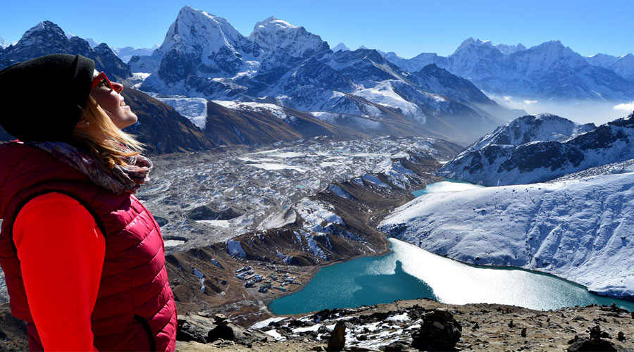
Gokyo Lake 1 is around 2 hours 40 minutes out of Macchermo. Behind the Gokyo settlements, you can see Cho Oyo dominate the background like a white wall. To the left of the settlement is the trail to Gokyo Ri. You get one of the best views of Everest range from here.
The tea house where you will halt at the end of today’s trail is situated around Gokyo Lake 3. |
| Day 7 |
Gokyo to Thangna; excursion to Gokyo Ri:
Altitude: Gokyo village (4,799 m) to (Gokyo Ri/5,334 m) & (Thangna/4,749 m)
Time taken: 6 hours to Gokyo Ri and back; 3 hours to reach Thangna
Trek gradient: Difficult. Steep ascent to Gokyo Ri. To Thangna, short steep ascent followed by 1.5 hours glacier walk. Gradual ascent after this.
Water sources: Start with carrying 2 litres of water. You can refill your water bottles at tea houses on the way.
Start the day by climbing Gokyo Ri. Though the mountain looks small, it will take 2-3 hours for you to reach the summit. From here, you will see the longest glacier in the Himalayas – Ngozumpa – flowing down, and the big mountains in front. You will also get a beautiful view of the Gokyo lakes behind you. Don’t forget to get photographed with Everest!
After an early lunch, head out to Ngozumpa glacier. You need to cross over this to get to Thangna, at the base of Chola Pass. Ngozumpa glacier is an unstable section of the trek that is prone to rockfalls so make sure you follow your guides. This is a beautiful glacier which is moving constantly, but you don’t feel the movement.
You will take an hour and a half to cross the glacier. Thangna is a mostly flat walk from here.
|
| Day 8 |
Rest day at Thangna:
Thangna is located at the foot of the Cho-La pass at an altitude of 4,750m. This is your rest day.
|
| Day 9 |
Thangna to Dzongla via Cho-la pass:
Altitude: Thangna (4,749 m) to Cho-la pass (5,366 m) & Dzongla (4,846 m)
Time taken: 9-10 hours
Trek gradient: Difficult. 4-5 km gradual ascent followed by 1 km of gradual descent. 1-1.5 km of trekking on boulders followed by 1 km glacier walk. 1 km steep descent on boulders easing off into a gradual descent.
Water sources: Start with carrying at least 2 litres of water. No water sources till you cross Cho-la pass.
Start your day early for Cho la Pass. It is going to be a long day. Cho la Pass is right behind Thangna. The ascent, which is quite a climb, has a lot of rubble and scree. The descent is tricky with a snowed out glacier and boulders. Stick to the right of the glacier and follow the guide strictly. Don’t venture on your own. Depending on the situation of the ice, crampons will be used.
After the boulder patch which is hard on your knees, it is a steep descent to Dzongla.
You will see Ama Dablam’s front view on this day. What a different side to this beautiful mountain! Please note that the teahouse at Dzongla has no Wifi. |
| Day 10 |
Dzongla to Labouche:
Altitude: Dzongla (4,846 m) to Labouche (4,938 m)
Time taken: 3 hours
Trek gradient: Moderate. Level walk throughout.
Water sources: Carry 2 litres of water; you will be covered.
The 3 hour walk to Labouche is mostly on a flat trail but you will be walking at quite an altitude. You will come across a junction where the trail splits to Pheriche and Labouche. Take the left. Views of Ama Dablam will accompany you till this point.
Around 90 minutes before Labouche, you will meet trekkers going on the traditional Everest highway. Helicopter sorties are commonplace here. |
| Day 11 |
Labouche to Gorakshep (Excursion to EBC):
Altitude: Labouche (4,938 m) to Gorakshep (5,151 m)
Time taken: 3 hours to Gorakshep
Trek gradient: Moderate. Short, steep ascent followed by 1.5-2 hours of boulder walk. Ends with a gradually ascending trail.
Water sources: Carry sufficient water. You will find teahouses on the way to Gorakshep.
It takes about 3 hours to reach Gorakshep, which is a very busy place. You will see the terrain change as you approach the place. There are a lot of trekkers coming in. You will see Everest Base Camp on the trail to Gorakshep.
After early lunch at Gorakshep, set off for EBC. Make sure you carry your day pack since you will need water. The climb is fairly moderate, though the moraines are slippery and the ridge bordering Khumbu glacier is very windy.
Everest Base Camp provides a very unique experience since you will see potential summiters. The climbers’ tents look striking against the backdrop.
Please note: drinking water at Gorakshep is chargeable. 1 litre of drinking water costs 350 to 500 Nepalese rupees. This is not included in the trek fee. Non potable water is available free of cost – if you are carrying a water purifying bottle, you could consider using that instead.
|
| Day 12 |
Climb Kala Pathar; Gorakshep to Pheriche:
Altitude: Gorakshep (5,151 m) to Pheriche (4,289 m), Kala Pathar is at (5,555 m)
Time taken: 8-9 hours
Trek gradient: Difficult. Gradual descent all the way to Pheriche.
Water sources: Carry sufficient water; you can refill your water bottles at tea houses on the way.
Start early for Kala Patthar so that you reach in time to watch the sun rising over the peaks. Kala Pathhar is the highest point of the trek.
The trail to Kala Patthar is well defined and will take you 2-2.5 hours to reach. The last section is steep.
From the summit, you will get great views of Everest, South Col – the traditional route to Everest summit. You will even be able to identify Hillary step.
There are great views of Lhotse, Makalu, the Khumbu glacier and icefall, and of the entire Everest Base camp. Pumori is straight ahead from the summit.
After spending some time at Kala Pathar, return to Gorakshep and start for Pheriche immediately after breakfast. Retrace the route back to Labouche, from where it’s another 3 hours to Pheriche.
You will cross Dughla/Thukla where there are memorials of mountaineers who died climbing Everest.
Pheriche is a village situated above the Tsola river. It is extremely picturesque and surrounded by mountains. There is a hospital in Pheriche, which was specially set up for the benefit of trekkers, and is currently run by the Himalayan Rescue Association with the help of volunteers from all over the world. The Ama Dablam Base camp is 4 hours from here. |
| Day 13 |
Pheriche to Tengboche:
Altitude: Pheriche (4,289 m) to Tengboche (3,860 m)
Time taken: 4-5 hours
Trek gradient: Moderate. 3 km gradual ascent to Tengboche.
Water sources: You can refill your water bottles at tea houses on the way.
This is the traditional Everest Highway. You will meet a lot of trekkers from around the world while walking on this trail.
The trail to Tengboche descends continuously from Pheriche.
Stop for the day at Tengboche. Visit the ancient Monastery here. Don’t be surprised if you come across renowned mountaineers here.
Tengboche has great views of the Everest, Nuptse, Lhotse and Ama Dablam. |
| Day 14 |
Tengboche to Namche Bazaar:
Altitude: Tengboche (3,860 m) to Namche Bazaar (3,445 m)
Time taken: 4 hours
Trek gradient: Moderate. Continuous descent followed by a final, short stretch of steep ascent.
Water sources: You can refill your water bottles at tea houses on the way.
You are back to walking along Dudh Kosi. From Tengboche, there is a steep descent to Phunki Thanga where you will have lunch.
You will see prayer wheels connected to a water turbine on the way. The water turbine ensures the wheels move clockwise. The climb from here to Namche is steep.
|
| Day 15 |
Namche Bazaar to Lukla:
Altitude: Namche Bazaar (3,445 m) to Lukla (2,840 m)
Time taken: 7-8 hours
Trek gradient: Moderate. Continuous descent to Phakding for a few hours followed by gradual ascent to Lukla.
Water sources: You will find tea houses on the way to refill your water bottles.
Descend down to Lukla on the same trail that you used to go up. Stop at Phakding for lunch.
You will reach Lukla in about 7-8 hours. Stay overnight at Lukla |
| Day 16 |
Fly back from Lukla to Kathmandu.
Fly back to Kathmandu, transfer to your hotel. End Services.
|